


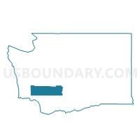
Curtis Voting District, Lewis County, Washington
About
Outline

Summary
| Unique Area Identifier | 687487 |
| Name | Curtis Voting District |
| County | Lewis County |
| State | Washington |
| Area (square miles) | 22.94 |
| Land Area (square miles) | 22.89 |
| Water Area (square miles) | 0.05 |
| % of Land Area | 99.76 |
| % of Water Area | 0.24 |
| Latitude of the Internal Point | 46.59085880 |
| Longtitude of the Internal Point | -123.15387160 |
Maps


Graphs
Select a template below for downloading or customizing gragh for Curtis Voting District, Lewis County, Washington


Neighbors
Neighoring Voting District (by Name) Neighboring Voting District on the Map
- Adna Voting District, Lewis County, WA
- Boistfort Voting District, Lewis County, WA
- Crego Voting District, Lewis County, WA
- Doty Voting District, Lewis County, WA
- Dryad Voting District, Lewis County, WA
- Mauermann Voting District, Lewis County, WA
- Meskill Voting District, Lewis County, WA
Top 10 Neighboring County Subdivision (by Population) Neighboring County Subdivision on the Map
Top 10 Neighboring Unified School District (by Population) Neighboring Unified School District on the Map
- Adna School District, WA (3,736)
- Pe Ell School District, WA (1,737)
- Boistfort School District, WA (894)